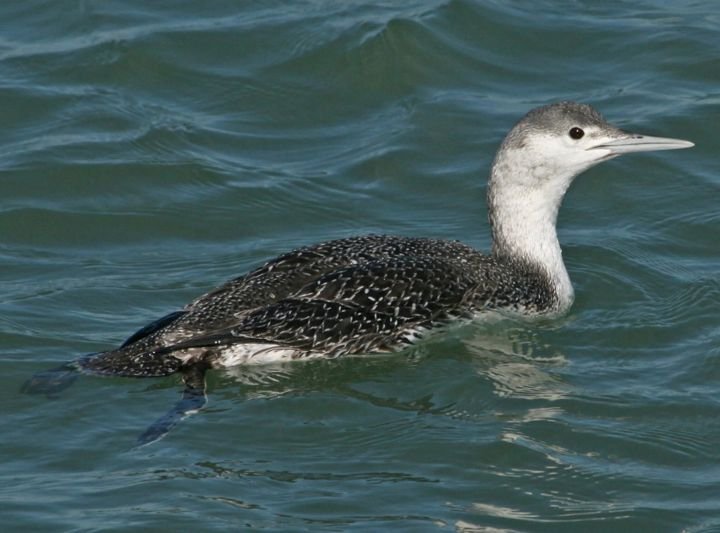
Photo: Dick Daniels · CC BY-SA 3.0
Gavia stellataRed-throated diver
110breeding pairsData from 2016 · Melrakkaslétta
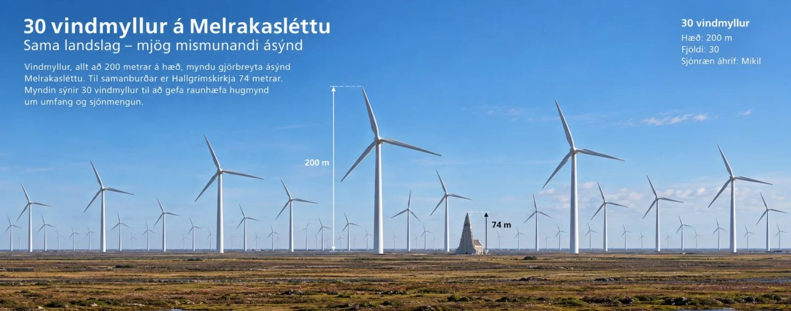
Concept image illustrating the proposed development. A more accurate view at the correct distance is in the 360° section. This is not a verified visualisation of Hnotasteinn; the location, number of turbines and visual proportions have not been verified. Background photo: Spike, Wikimedia Commons, CC BY-SA 4.0.
Untouched wilderness is precious and rare in Europe.
A wind farm on Hólaheiði at Hnotasteinn would have a major visual impact on a large, largely untouched area and could affect its rich birdlife. The impact would be permanent and irreversible. We call on Norðurþing municipal council to abandon plans for an industrial zone on Hólaheiði.
After a re-assessment, the Master Plan project board again proposes that Hnotasteinn be placed in the on-hold category – not the energy-use category. Public comments can be submitted in the government consultation portal until 4 January 2027. Norðurþing municipal council has not taken a formal position. The decision is still open – the petition runs until 16 December 2026.
View timeline ↓Two recordings by Magnús Bergsson. One was made on Hólaheiði in Melrakkaslétta, the other next to wind turbines.
Sound recordings: Magnús Bergsson, Hljóðmynd – fieldrecording.net. Four-minute excerpts from longer recordings, made at different locations with different equipment; volume is as recorded. Photo: Magnús Bergsson.
360° photo taken in Melrakkaslétta on 3 October 2026. The 30 turbines are inserted at the correct size and distance, 12–17 km from the camera. The “3 km” and “500 m” buttons show examples of how they would look closer up, for instance from a farm, a road or a hiking area.
Drag to look around, zoom with the mouse wheel or two fingers. The “Fela vindmyllur” (hide turbines) button shows the landscape as it is today. The controls inside the 360° viewer are in Icelandic. 360° photo and processing: Sigursteinn Baldursson, Kúlumyndir 32.
Open full screen ↗On 13 October 2026 the project board of Iceland’s Master Plan for Nature Protection and Energy Utilisation published a new assessment of seven wind power proposals. Hnotasteinn scores worst for nature, yet it is not proposed for the protection category but for the on-hold category 33.
By far the highest of the seven sites. Next comes Sólheimar with 12. The project board describes the impact as very negative.
The highest score of all seven sites from expert group 1.
Highest of the seven – the other sites range from 0.4 to 2.8. Bedrock also gets the highest score: 6.4.
Four sites with less impact on nature go into the protection category. Hnotasteinn, with the greatest impact, is put on hold. The classification does rest on more factors – Mosfellsheiði, for example, scored highest for impact on outdoor recreation (10 of 10) – but nowhere does Hnotasteinn come out well for nature 33.
Hnotasteinn is not in a core wilderness area according to wilderness mapping, although some turbines may be visible from it. There would be up to 30 turbines, up to 200 m tall and up to 7.2 MW each.
Friðjón Þórðarson, CEO of Qair Ísland · Vísir, 12 May 2026 34“Very negative impact on unspoiled wilderness.” Wilderness scores 16.8 of 20 – more than any other site. And 30 turbines × 7.2 MW = 216 MW, the same figure as the larger version in the Master Plan assessment.
Report of the 6th-phase project board · October 2026 33The petition goes to Norðurþing municipality. A comment in the government consultation portal (Samráðsgátt) goes straight to the Master Plan project board, which submits its final proposal to the minister in February 2027. Every comment is read and published.
A comment in your own words carries more weight than identical text from many people. Use the draft as a starting point. Submitting requires an Ísland.is login.
Hnotasteinn is Qair Iceland’s wind power project on Hólaheiði, about 6.5 km east of Kópasker. Below are the key figures according to the developer.
Installed capacity is not continuous output, and the final turbine model has not been chosen. The 2021 scoping document assumed 34 turbines and 200 MW 06, and the Master Plan assesses the option at about 220 MW 05.
Each turbine comes with a concrete foundation up to 30 m in diameter, a crane pad and a road. Qair roughly estimates 21,000 m³ of concrete and 1,800 tonnes of steel for the foundations of 30 turbines 02. According to the scoping document, about 17 km of new roads would be needed within the area, plus about 250,000 m³ of fill material 06.
Qair believes the project could create jobs, increase electricity supply and support infrastructure 01. Few permanent jobs are expected during operation 06. The Master Plan project board noted that the cost of connecting to the transmission grid is very high, ISK 10–14 billion 05.
On Hólaheiði in Núpasveit, in the middle of Melrakkaslétta. The heath is flat – vegetated moorland, post-glacial lava and small lakes. The study area covers 3,330 ha.
Satellite image from Google. You can pan and zoom the map to explore the heath.
| Component | Size | Area | Duration |
|---|---|---|---|
| Turbine foundations | Up to 30 m in diameter | 2.4 ha | Permanent |
| Turbine footings | 1,610 m² each | 5.5 ha | Permanent |
| New roads and underground cables | 17,000 × 4.5 m | 45.9 ha | Permanent |
| Collector station, substation and offices | 3,000 m² | 0.3 ha | Permanent |
| Turbine work pads | 2,240 m² each | 7.6 ha | 1 month |
| Material storage | 1,640 m² | 5.6 ha | 10 months |
Reference model: Vestas V162‑5.6 MW, hub height 119 m and 162 m rotor diameter. Construction about 12 months, probably spread over two years, with up to 100 workers. Operating life at least 25 years. Connection to Landsnet’s substation at Snartarstaðir via 33 kV underground cables 06.
The heaths, lakes and wetlands of Melrakkaslétta are part of an internationally Important Bird Area. Red-throated diver, great northern diver and gyrfalcon are among the species recorded in data from the Icelandic Institute of Natural History 03.
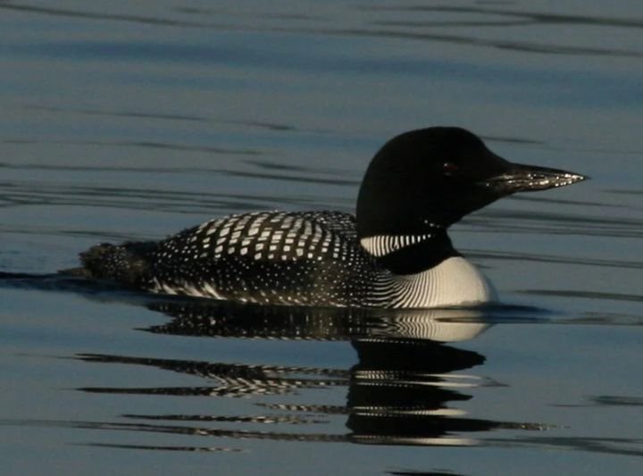
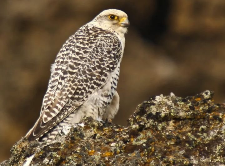
About the data. The figures apply to the wider Melrakkaslétta area, not only Hnotasteinn. They are historical data from 2016, not a new count or a forecast of bird deaths.
About the photos. The photos show the species and were not taken in Melrakkaslétta. The red-throated diver is in winter plumage.
Melrakkaslétta is on Iceland’s Nature Conservation Register, listed for its birds and its freshwater and shoreline habitats 03. Rock ptarmigan and greylag goose are classed as near threatened on the new 2025 Red List of birds 27. Ptarmigan fly a lot at dusk, when observers are not in the field. Local people have asked what level of bird mortality would be considered acceptable 06.
The area is uninhabited and largely undisturbed. Visibility is to be assessed up to 45 km from the outermost turbines; Norðurþing’s municipal plan states that disturbance of untouched wilderness should be avoided 06.
Hólaheiði is free of light pollution, and there has been talk of using it for northern lights and stargazing 06. Turbines over 100 m must be lit for aviation safety.
The westernmost part of the area contains wetland of very high conservation value, partly on post-glacial lava. Both enjoy special protection under the Nature Conservation Act 06.
The old route Hólsstígur runs along the edge of the area, a hiking and riding trail crosses it, and it is used for cross-country skiing.
The Arctic Coast Way and the Bird Trail (Fuglastígur) pass nearby. Kópasker has guesthouses, an Earthquake Centre and a bird hide.
Here we review what the scoping document says about groundwater, and what research says about microplastics and epoxy shed from turbine blades.
According to the scoping document, water seeps easily into the lava in the area, so the groundwater may be vulnerable to pollution. At the south-western edge of the area is an outer water protection zone, and several lakes and ponds within it are specially protected 06.
The greatest risk is during construction: about 17 km of new roads, about 250,000 m³ of fill and thousands of cubic metres of concrete. During operation, about 500 litres of oil per turbine might be needed every five years 06. The developer says concrete will not be mixed on site and materials will not be stored there.
Rain, hail and windblown sand gradually erode the leading edge of the blades, so particles of coating and epoxy break off and fall to the ground. A study at DTU in Denmark estimates the emission at 8–50 g per year for each onshore blade 13.
For 30 turbines with three blades each, that is about 0.7–4.5 kg per year, or about 18–110 kg over a 25-year operating life. That is small compared with other sources such as tyre wear 13. Estimates of bisphenol A (BPA) emissions suggest they are very low 15.
No research has been carried out in Melrakkaslétta on how particles from blades – microplastics and epoxy – would affect soil and groundwater. Most existing studies were done offshore or in Denmark and the Netherlands, in conditions very different from the porous lava and wetlands of Hólaheiði, where water passes easily down to the groundwater. The rate of erosion depends on weather, and volcanic sand and hail can increase it. We believe this uncertainty belongs in the environmental impact assessment.
Note: A 2021 Norwegian report is often quoted as estimating 62 kg per turbine per year 16. A later peer-reviewed study showed that a percentage from small test samples had been wrongly applied to whole blades 14, so we do not use that figure.
Three facts about the blades that would turn above Hólaheiði.
In 2013, about 27% of all epoxy used in Europe went into wind turbine blades 16. The most common epoxy is made from bisphenol A (BPA), a substance many countries have restricted in consumer products.
Based on a turbine such as the Vestas V162: maximum rotor speed 10 revolutions per minute and a 162 m rotor diameter 18. The blade tip therefore travels at about 300 km/h, many times faster than birds generally fly. See comparison ↓
Each turbine sweeps about 20,600 m² 18, the size of about three football pitches. With 30 turbines that would be over 60 hectares of airspace where red-throated divers, great northern divers, greylag geese and ptarmigan fly.
The speed of some Icelandic birds compared with a turbine blade tip, in km/h. None of them reaches the blade tip – not even a gyrfalcon in a dive.
The figures come from different measurements (migration, hunting, diving) and are indicative, not a precise comparison. For golden plover, a measurement of grey plover, a closely related species, is used. In theory a gyrfalcon could reach up to 250 km/h in a very long dive 23.
Hnotasteinn would have 30 turbines and 90 blades, each about 80 m long. Laid end to end they would stretch about 7.2 km – further than from the project site to Kópasker.
Each blade is about 80 m long – longer than Hallgrímskirkja church is tall (74.5 m). The 90 blades would stretch as far as the Vaðlaheiði tunnel and be more than three times the length of the whole of Laugavegur.
Blades made of glass fibre and epoxy are hard to recycle, and thousands of tonnes have ended up in landfill. The European wind industry association itself admits that recycling solutions are neither sufficiently developed nor cost-competitive. The industry adopted a voluntary landfill ban from 1 January 2026, but it is a sector commitment, not law 17. Who will pay when the blades are taken down?
From comments submitted on the scoping document in autumn 2020 06.
“I really love this untouched land on Hólaheiði, completely free of light pollution, which shows you the moon, the stars and the northern lights.” She asks whether the turbines will be seen or heard from the churchyard, the folk museum and hiking trails.
Objected to the area being described as remote with little tourism. Pointed to accommodation, the Earthquake Centre, the Snartarstaðir Folk Museum, the artwork Dansinn, Hallveigarlundur, the Bird Trail and the Arctic Coast Way.
Untouched wilderness is sought after by hikers and outdoor enthusiasts. A large area of this kind would be spoiled, a good cross-country skiing area destroyed, and the ancient route Hólsstígur must not be disturbed.
The wide open views on Hólaheiði make the area unique for enjoying the northern lights and stargazing, and there has been talk of using it for winter tourism.
The ptarmigan population is at a historic low and the birds should be given the benefit of the doubt: two years of research are needed unless it is shown that no sensitive species pass through the area.
It must be defined what level of bird mortality is acceptable and how to respond if it turns out higher than expected – and whether the developer would then be prepared to stop operating.
Here are confirmed milestones from available sources. A proposal, a review and a permit are different steps.
Sources reviewed in September 2026.
Read the original sources ↓Qair presented a proposed scoping document for 34 turbines and 200 MW. 13 parties submitted comments. The National Planning Agency approved the proposal with comments in 2021 06 07.
Norðurþing’s municipal executive postponed a change to the municipal plan after protests from residents around Öxarfjörður 09. At the end of August the council unanimously agreed to postpone planning changes until the environmental impact assessment was complete 11.
The 5th-phase Master Plan project board submitted a proposal classifying ten wind power options. Hnotasteinn was proposed for the on-hold category, partly because of uncertainty about impacts on birdlife, social impacts and grid connection costs 05.
The then majority of Norðurþing municipal council asked for Hnotasteinn to be re-assessed and moved from the on-hold category to the energy-use category 08.
After the municipal elections on 16 May, the Independence Party, the Social Democratic Alliance, the Progressive Party and Óskalisti formed a new majority in Norðurþing 28.
Iceland’s parliament adopted stricter rules for wind power. The position of municipalities becomes a fundamental factor in the Master Plan’s assessment of wind power options, with particular attention to impacts on birdlife and wilderness 29.
The council stated that it had not taken a formal position on the development. Emphasis was placed on consultation and a comprehensive assessment of impacts 04.
Hnotasteinn was re-assessed in the 6th phase of the Master Plan. The project board again proposes the on-hold category – not energy use. The impact on unspoiled wilderness is rated the greatest of seven wind power options and considered likely to limit opportunities for tourism and outdoor recreation. Comments can be submitted in the consultation portal until 4 January 2027 33. See the new assessment ↑
Under the new law, Norðurþing’s position carries great weight. As long as the council has not taken a position, the voice of residents and the public can make a difference. Sign the petition ↓ Comment on the Master Plan ↗
We believe Melrakkaslétta should not become an industrial zone for a large wind farm.
Our position is based on the importance of nature, birdlife and landscape. We believe the location of renewable energy production matters and that the natural values of Melrakkaslétta should weigh heavily in the decision.
Skrifa rafrænt undir á Ísland.is með rafrænum skilríkjum ↗No. Our position is about location. We believe the natural values of Melrakkaslétta should weigh heavily when deciding where wind farms are built.
That is not final, as the turbine model has not been chosen. The scoping document assumed a blade tip reaching about 200 m above ground, and Qair cites the same maximum height 02 06.
No. The figures for red-throated diver, great northern diver and gyrfalcon are 2016 data for the whole of Melrakkaslétta. They show which species the area supports, but are neither a count at Hnotasteinn nor a forecast of bird deaths 03.
No. In January 2026 the previous majority asked for Hnotasteinn to be moved to the energy-use category, but according to minutes of 17 September 2026 the new council has not taken a formal position 04 08.
The law adopted by parliament on 19 June 2026 rules out wind farms in protected areas, Ramsar sites and areas on Part B of the Nature Conservation Register. Hólaheiði does not fall into those categories, so Hnotasteinn is not automatically excluded. However, the law makes the municipality’s position a fundamental factor in the Master Plan assessment – which is why Norðurþing’s position, and your signature, matter 29 31.
Under Act No. 48/2011, the on-hold category is for options considered to need more information before it can be decided whether they go into the energy-use or protection category. Hnotasteinn is therefore neither approved nor rejected. In the project board’s report (October 2026), Hnotasteinn receives the highest score of seven wind options for impact on unspoiled wilderness (16.8 of 20), and expert group 1 rates it the option with the greatest impact on natural and cultural heritage. The proposal is open for consultation until 4 January 2027 and anyone can submit a comment 33.
No. The area is not protected. Melrakkaslétta is on the Nature Conservation Register as “other natural heritage” and designated an internationally Important Bird Area. It is not among the seven areas parliament placed on Part B of the register in November 2025 30. Wetlands and post-glacial lava in the area enjoy special protection under the Nature Conservation Act 03 06.
Signing takes place on the official petition service of Ísland.is, and you identify yourself with Icelandic electronic ID. This ensures that every signature belongs to a real person. Signing therefore requires an Icelandic ID number (kennitala) and electronic ID.
“The land is fair and free”– Jónas Hallgrímsson, Ísland (1835)
The petition closes 16 December 2026
We, the undersigned, oppose plans to build a wind farm on Hólaheiði at Hnotasteinn. The proposed development would have a major visual impact on a large area that is otherwise largely untouched and characterised by few visible structures. The project could also affect the area’s rich birdlife. Untouched wilderness is precious and rare in Europe. Such a development would have a permanent and irreversible impact on the landscape, the experience of nature and the image of the area. It could affect residents’ quality of life, outdoor recreation and tourism in the area. We call on Norðurþing municipal council to abandon plans for an industrial zone on Hólaheiði.Skrifa rafrænt undir á Ísland.is með rafrænum skilríkjum ↗
You will be taken to Ísland.is, where the petition is in Icelandic. Signing requires Icelandic electronic ID. No ID? You can still help by sharing this page. This site collects no personal data.
Developer plans, research data and official minutes are each labelled separately.
Last updated 19 October 2026. Older data may refer to a different design. We link each key claim to the source it is based on. Most sources are in Icelandic.